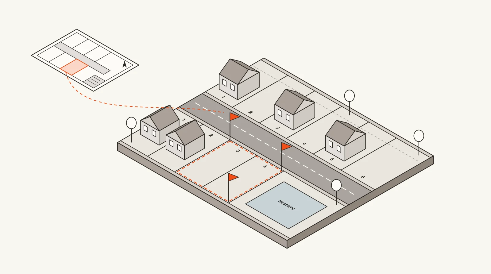
A plat, in plain English
A plat (also called a plat map or subdivision plat) is a scaled drawing that divides a tract of land into lots, blocks, streets and easements. A licensed surveyor prepares it, the city or county approves it, and then it's recorded in the county's public records. From that point on, each lot can be sold and described by its lot and block number instead of a long metes-and-bounds description.
Plats are public records. Anyone can look one up, usually through the county clerk's map records or the appraisal district's map. Our Texas plat map guide shows where to find them county by county.
What's on a plat
- The subdivision name and section, like "Oak Forest Section 2".
- Every lot and block, numbered, with its dimensions and often its square footage or acreage.
- Streets, alleys and their right-of-way widths, dedicated to the public.
- Easements for utilities, drainage and access, and building setback lines.
- Reserves: land set aside for detention ponds, parks, landscaping or future commercial use.
- Notes and restrictions, flood zone information, and the surveyor's seal and the approval signatures.
- The recording information (volume and page, or cabinet and slide) once it's filed with the county.
What is platting? How land gets platted in Texas
Platting is the process of getting a plat approved and recorded. In Texas it's governed by the Local Government Code: Chapter 212 for land inside a city or its extraterritorial jurisdiction (ETJ), and Chapter 232 for unincorporated county land. Most land has to be platted before it can be divided into lots for sale or get a building permit.
- 1
Preliminary plat
The developer's surveyor and engineer submit a draft layout: lot lines, streets, drainage, utilities. Staff and the planning commission review it against the city or county's subdivision rules. It's not recorded, and lots can't be sold from it.
- 2
Final plat
Once engineering is settled, the final plat is submitted with exact dimensions and signatures. Since 2019, Texas cities and counties have to approve, conditionally approve or deny a complete plat application within 30 days, so approvals move on a fixed clock.
- 3
Recording
The approved final plat is filed with the county clerk and gets a recording reference. Now the lots legally exist, can be sold, and can be permitted for construction.
Preliminary plat vs. final plat
- Purpose: a preliminary plat tests the layout; a final plat is the legal document.
- Detail: the preliminary shows the general design; the final has exact bearings, distances, lot areas and easements.
- Recorded? Only the final plat is recorded with the county. A preliminary plat can't be used to sell lots.
- Timing: a preliminary plat often comes 3 to 12 months before the final, and the final usually comes shortly before streets and utilities go in.
What is a replat?
A replat changes a plat that's already recorded: combining two lots into one, splitting a lot into several, moving a lot line, or redrawing part of a subdivision. In Houston, replats are how one old lot becomes two or three townhome lots, which is why so many inner-loop neighborhoods change one lot at a time.
Texas also allows an amending plat for small fixes, like correcting a dimension or relocating a lot line between neighbors, without the full process. Some replats, especially in older residential subdivisions, require notice to nearby owners and a public hearing. If a sign goes up on your street announcing a replat hearing, that's where to raise questions.
Plat vs. survey (and what people mean by "plat survey")
A plat covers a whole subdivision and is a public record. A survey covers one property. A Registered Professional Land Surveyor walks the lot and draws its boundaries, the house and other improvements, fences, easements and any encroachments, usually for a sale or a loan.
When people say "plat survey," they usually mean the survey of their lot, which is drawn from the recorded plat. In a Texas home sale, the title company often accepts the seller's existing survey with a T-47 affidavit stating nothing has changed; otherwise a new survey is ordered.
- Need to know your lot's official dimensions or easements? Look up the plat.
- Need to know where your fence or house sits relative to the lines? You need a survey.
- Building, adding on or putting in a pool? The city will usually want a survey or site plan, and the plat's setbacks and easements decide what you can build where.
New plats filed in Houston
Houston has no zoning, so new neighborhoods show up first as plats before the Planning Commission, every two weeks. Here's what was on recent agendas. Each one is a future street of homes or a new commercial site.
- 661
- plats on the agenda, last 90 days
- 6,620
- lots proposed
- 26,655
- acres platted
- Haddick PlaceDec 3, 20263 lots · 0.29 ac · Single Family Residential (Public Street) · East Houston
- ARG Chetti HoldingsDec 3, 20261.20 ac · Commercial · 77406
- Reserve at Spring BranchDec 3, 202670 lots · 4.65 ac · Landscape or Open Space; Residential Guest Parking; Single Family Residential (PAE 1/PAE 2) · Spring Branch Central
- Morse Street ViewsDec 3, 20262 lots · 0.11 ac · Single Family Residential (Public Street) · Neartown - Montrose
- Northwest Place Partial ReplatDec 3, 202614.71 ac · Unrestricted · Fairbanks / Northwest Crossing
- Spring Dell DevelopmentDec 3, 20260.61 ac · Unrestricted; Commercial · 77388
Why builders and trades watch plats
A recorded plat is the earliest public sign that homes are coming: lot count, acreage and the developer's name, often six to twelve months before the first house permit. Homebuilders use plats to find lots, and trades and suppliers use them to get in front of builders before a new section starts. groundranger tracks Houston plats alongside building permits, so you can watch both.
groundranger Pro
Get new plats and permits by email
Everything above, checked for you every morning. Pick your ZIP codes and the kind of work you want, and we email you new filings with the owner, contractor and design firm already attached.
Questions
What is a plat in real estate?
A recorded map that divides land into numbered lots and blocks, with streets and easements. It's the reason a property can be described as "Lot 12, Block 3" of a named subdivision in a deed.
What is the difference between a plat and a survey?
A plat maps a whole subdivision and is recorded with the county. A survey maps a single property as it exists today, including the house, fences and any encroachments, and is usually ordered for a sale or a loan.
What does platted mean?
Platted land has an approved, recorded plat, so it's legally divided into lots. Unplatted land is still one tract, described by metes and bounds, and usually can't be sold off as lots or permitted for homes until it's platted.
What is a replat?
A revised plat for land that's already platted, used to combine, split or reconfigure lots. Some residential replats in Texas require notice to neighbors and a public hearing.
How long does platting take in Texas?
Once a complete final plat is filed, Texas cities and counties must act on it within 30 days. The whole process, from preliminary plat through engineering to recording, often takes several months to a year for a new subdivision.
Where can I find the plat for my property?
Find your lot and block in the county appraisal district's record, then look up the recorded plat in the county clerk's map records. Our Texas plat map guide walks through it for the largest counties.