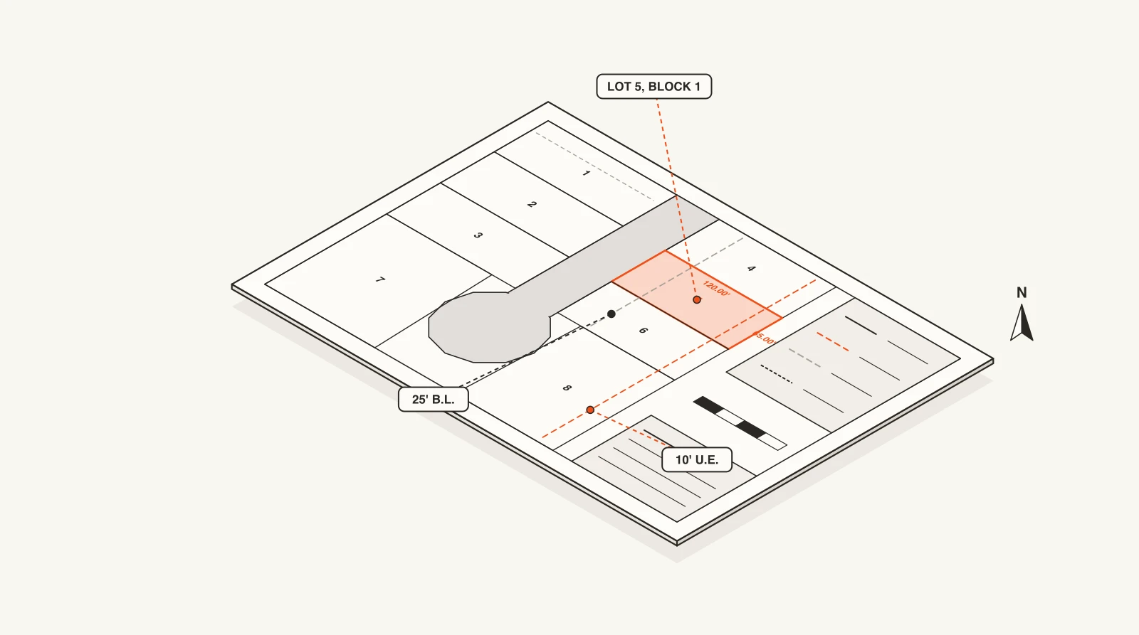
What a plat map is
A plat map is the drawing part of a recorded plat: the scaled map that divides a tract into lots, blocks, streets, easements and reserves. Once it's approved and recorded with the county, its lines are the legal lot lines. When a deed says "Lot 12, Block 3, Oak Forest Section 2," the plat map is where that lot is drawn.
If you don't have the plat yet, our Texas plat map lookup guide shows how to find it through the appraisal district and county clerk in a few minutes.
How to read a plat map, step by step
Plats vary a little by county and surveyor, but they all follow the same anatomy. Read them in this order:
- 1
Start at the title block
Usually in the lower right corner. It names the subdivision and section, the survey or abstract the land sits in, the city and county, the owner, the surveyor and engineer, the scale and the date. The county's recording stamp (volume and page, film code or instrument number) tells you it's the recorded version, not a draft.
- 2
Orient yourself with the north arrow and scale
Every plat has a north arrow and a stated scale, often 1 inch = 100 feet, plus a vicinity map showing where the subdivision is. Check which way is north before you reason about which street a lot faces.
- 3
Find your lot by block and lot number
Lots are numbered within blocks, and blocks are numbered or lettered within the subdivision. "Lot 12, Block 3" is a direct address: find Block 3, then Lot 12 inside it.
- 4
Trace the boundary with bearings and distances
Each lot line is labeled with a bearing (a compass direction like N 45°30'15" E) and a distance in feet. Curved lines along cul-de-sacs and bends refer to a curve table with the radius, arc length and chord. Following them around the lot traces its exact legal boundary.
- 5
Check the dashed lines
Dashed or dotted lines are almost always easements or building lines, labeled with a width and purpose, like "10' U.E." for a ten-foot utility easement or "25' B.L." for a 25-foot building line. These decide where you can and can't build.
- 6
Read the plat notes
The fine print along the margins: building lines, drainage and detention requirements, flood zone statements, restrictions on reserves, and the dedication language. They apply to every lot on the plat, so read them even if your lot looks simple.
Plat map symbols and abbreviations
Each plat has a legend that defines its own symbols, but these are the ones you'll see on most Texas plats:
- B.L. (building line): the setback from the street or lot line. No building can sit in front of it.
- U.E. (utility easement): a strip reserved for power, water, sewer, gas or telecom lines, usually along the back or side of a lot.
- D.E. (drainage easement): a strip kept open for stormwater, often a swale or storm sewer. You generally can't build over it.
- A.E. (aerial easement) or access easement: space for overhead lines, or a right to cross one lot to reach another. The legend says which.
- R.O.W. (right-of-way): land dedicated for a public street or alley, labeled with its width, like "60' R.O.W."
- Reserve or Restricted Reserve: a tract that isn't a home lot, set aside for detention, landscaping, a park, utilities or future commercial use. The note says what it's restricted to.
- Bearings like N 45°30'15" E: the compass direction of a line, in degrees, minutes and seconds east or west of north or south.
- Curve table (R, L, CH, Δ): the radius, arc length, chord and central angle for each numbered curve on the map.
- I.R.S., I.R.F., I.P.F. (iron rod set, iron rod found, iron pipe found): the survey monuments at lot corners, the physical markers in the ground.
- Sq. ft. or Ac.: the lot's area, in square feet or acres.
Plat map vs. survey vs. site plan
Put simply: the plat defines the lot, the survey shows what's on it, and the site plan proposes what will go on it. Our plat guide covers the plat vs. survey difference in more detail.
- Plat map: covers a whole subdivision, is recorded with the county, and creates the lots. It shows lots as legally defined, usually before anything is built. It's a free or cheap public record.
- Survey: covers one property as it exists today, with the house, fences, driveway, easements and any encroachments. It's ordered from a licensed surveyor by an owner, buyer or lender, usually for a sale or a loan.
- Site plan: a design drawing of what someone intends to build on a lot: buildings, parking, utilities, landscaping. It isn't recorded and doesn't change the lot lines.
Reading a plat map like a builder
A title company reads a plat for boundaries. Builders, trades and suppliers read it for what's coming. On a new plat, these are the fields that matter most:
- Lot count and lot size. Forty 50-foot lots is a production homebuilder's section. Four large reserves is commercial development. The trades needed follow from that.
- The owner in the title block. Usually an LLC. Look up who's behind it and you've found the developer, and often the builder.
- The surveyor and engineer. Civil firms tend to work with the same developers again and again, so the firm on the plat hints at who's building.
- Reserves and what they're restricted to. "Restricted Reserve A, detention" means site work. "Restricted Reserve B, commercial" is a future building.
- New street dedications. New streets mean paving, water, sewer and drainage contracts long before the first house permit.
New plats filed in Houston
Houston publishes new plats on each Planning Commission agenda, every two weeks, before they're recorded. Here's what was on recent agendas. Open any of them to see the lots, acreage and developer, or browse all Houston subdivisions and plats.
- 661
- plats on the agenda, last 90 days
- 6,620
- lots proposed
- 26,655
- acres platted
- Haddick PlaceDec 3, 20263 lots · 0.29 ac · Single Family Residential (Public Street) · East Houston
- ARG Chetti HoldingsDec 3, 20261.20 ac · Commercial · 77406
- Reserve at Spring BranchDec 3, 202670 lots · 4.65 ac · Landscape or Open Space; Residential Guest Parking; Single Family Residential (PAE 1/PAE 2) · Spring Branch Central
- Morse Street ViewsDec 3, 20262 lots · 0.11 ac · Single Family Residential (Public Street) · Neartown - Montrose
- Northwest Place Partial ReplatDec 3, 202614.71 ac · Unrestricted · Fairbanks / Northwest Crossing
- Spring Dell DevelopmentDec 3, 20260.61 ac · Unrestricted; Commercial · 77388
See what's been permitted on a lot
A plat tells you what the lot is. Permits tell you what's been built on it. Search an address to see every permit and project filing on record there.
groundranger Pro
Get new plats and permits by email
Everything above, checked for you every morning. Pick your ZIP codes and the kind of work you want, and we email you new filings with the owner, contractor and design firm already attached.
Where the plat came from
Every recorded plat went through the same approval steps. See the platting process for how a plat gets from a surveyor's draft to the county records, preliminary vs. final plats for the two approval stages, and plat vs. replat for how recorded lots get changed later.
Questions
What is a plat map?
The recorded, scaled drawing of a subdivision. It shows every lot's boundaries and dimensions, the block and lot numbers, streets and their right-of-way, easements and reserves, plus the surveyor's seal and the approval signatures.
How do I read the bearings and distances on a plat?
Each lot line has a bearing, a compass direction such as N 45°30'15" E, and a distance in feet. Starting at one corner and following the bearings and distances around the lot traces its legal boundary. Curved lines refer to a curve table with the radius and arc length.
What do the dashed lines on a plat map mean?
Usually easements or building lines. Each is labeled with its width and type, such as "10' U.E." for a utility easement or "25' B.L." for a building setback. Solid heavy lines are the subdivision boundary and lot lines. The plat's legend has the exact convention.
What does B.L. mean on a plat?
Building line: the setback from the street (or another lot line) that no building can be placed in front of. It's set by the plat and the city or county's subdivision rules.
Does a plat map show my house?
No. A plat shows lots as legally created, usually before anything is built. To see where your house, fences and driveway sit relative to the lot lines, you need a survey.
How current is a plat map?
A plat shows the subdivision as recorded on its date and never updates. If lots were later split, combined or adjusted, look for a replat, which replaces the original for the lots it covers.